Minnesota Statewide Altered Watercourse Project
The goal of this project was to develop and deliver a statewide Geographic Information Systems (GIS) tool that would delineate those portions of the National Hydrography Dataset (NHD) that have been visually determined to be hydrologically modified (i.e., ditches, channelized streams and impoundments). This project was conducted in support of the Minnesota Pollution Control Agency’s water quality monitoring and assessment program, with support from the Clean Water, Land, and Legacy Amendment.
Specifically, the MPCA is developing a refined stream use designation process
known as
Tiered Aquatic Life Uses (TALU). An accurate statewide determination
of altered stream segments based upon the current NHD linework will assist in
the assignment of the correct beneficial use class for a stream under the TALU
framework. The NHD does not provide an accurate representation of the number of
altered stream miles within Minnesota, therefore this project will utilize
multiple types of information (e.g., LiDAR, aerial imagery, historic aerial
photographs, and observations from on-the-ground surveys) to determine the
extent of stream modifications. This project provides the first baseline
account of the extent of hydrologic alterations in the state of Minnesota. This
project was completed on June 30, 2013. See Statewide Project Information
section to download large-scale project map and final project data.
Project Partners | Methodology | Project Schedule | Project Deliverables | Meeting Minutes/Information | Project Participants
______________________________________________________________________________![]()
Project Partners
- Minnesota Pollution Control Agency
- Minnesota Geospatial Information Office
- Minnesota Department of Natural Resources
Original source of funding was provided by the
Clean Water Fund of the
Clean Water, Land and Legacy
Amendment
_______________________________________________________________________________
Methodology
This project utilized a GIS and multiple data sources (e.g. LiDAR, 2001 – 2010 aerial imagery, historic air photographs) to make a visual determination regarding the hydrologic conditions of all streams within the state of Minnesota.
Examples of how data are used to determine hydrologic alteration with a stream:
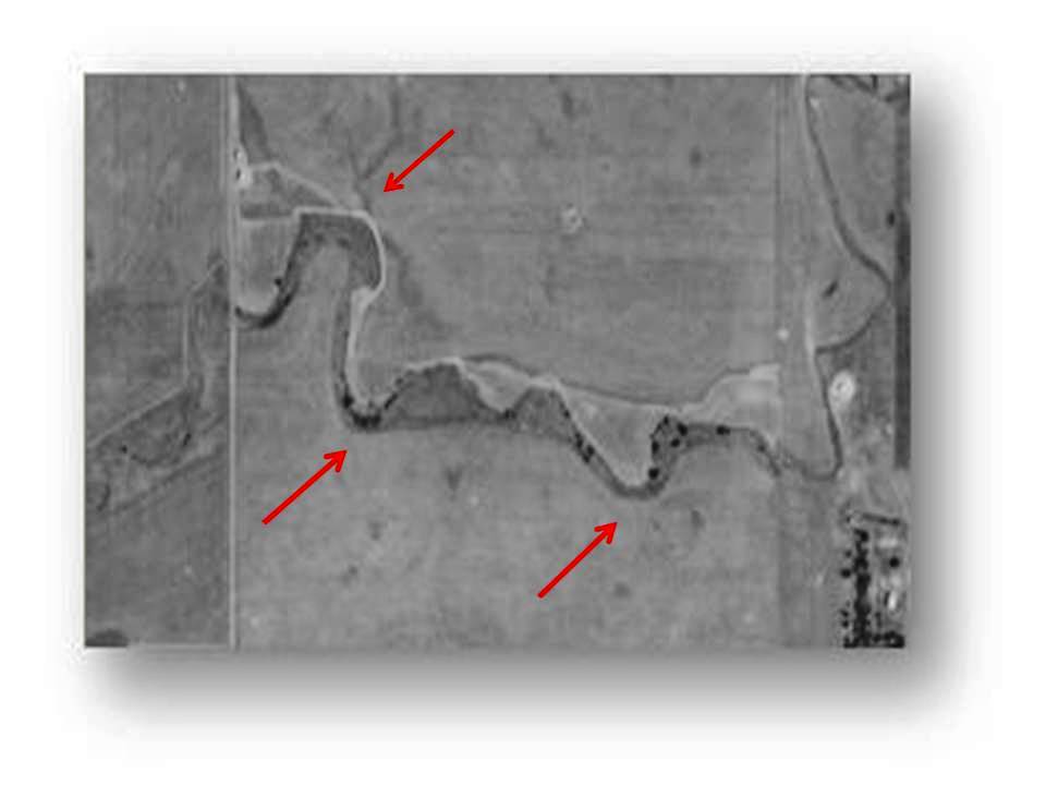
Figure 1: Aerial photograph from 1938. Red arrows indicate natural bends (sinuosity) in the stream.
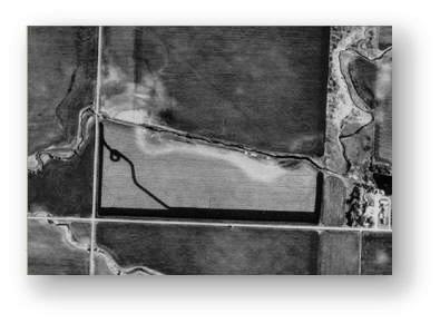
Figure 2: 1991 leaf-off aerial imagery. Note that the natural bends from the 1938 aerial photographs no longer are connected to the stream.
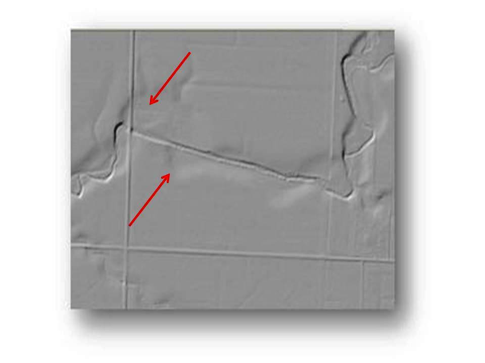
Figure 3: LiDAR imagery (hillshade function). LiDAR imagery provides further indication that the natural stream channel has been ditched. Red arrows highlight the remnants of the natural bends. In this figure you are also able to see the dredge piles created as a result of channelization.
2008 Pilot Project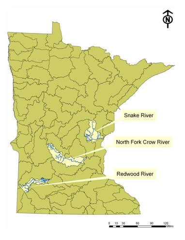
In 2008, the Land Management Information Center (now MnGeo) undertook a pilot project to develop a methodology to distinguish between natural and altered watercourses and to create a ‘natural/altered watercourse’ tool tied to the high-resolution NHD. The pilot project evaluated portions of several 8-digit HUC watersheds in different parts of the state in order to create a methodology that would work under the full range of hydrologic regimes found throughout Minnesota. During the pilot effort, areas were chosen in the North Fork Crow River (07010204), Snake River (St. Croix Basin - 07030004), and Redwood River (07020006) watersheds. (Click on thumbnail to view a larger version of this map). The method development effort included review of results by MPCA staff and quality control against site information assembled by MPCA.
The statewide project built upon the efforts completed in the 2008 project and refined the methodology, created new tools to aid in data processing, added additional layers (e.g., LiDAR and 2009-2011 aerial imagery), and completed a comprehensive visual analysis of all streams statewide.
_____________________________________________________________________________
Project Schedule
The total project area encompassing approximately 100,000 miles of streams across 87 counties was broken up into 3 phases as shown on this map. Click on thumbnail at right to view a larger version of the map.
Phase I (orange) – This phase encompasses 27,467 square miles with a majority of watersheds representing the Red River basin; however three watersheds (Minnesota River-Yellow Medicine, Mississippi River-Twin Cities, and Mississippi River-Winona) were also added to this delineation schedule. These three watersheds were added because the MPCA will perform water quality assessments on these watersheds in the coming year, therefore having these data available during assessments will allow for further understanding of habitat modifications within a particular watershed. This phase was completed spring-summer 2012.
Phase II (blue) – This phase encompasses 32,119 square miles with watersheds representing the Minnesota River, Lower Mississippi River, and Central Lakes basins. This portion was completed by summer-fall 2012.
Phase III (green) – This phase covers 24,781 square miles representing watersheds within the Arrowhead and Central Lakes Basin. This portion was completed fall 2012-spring 2013.

_______________________________________________________________________________
Project Deliverables
- Watercourse delineations for all portions of the National Hydrography Dataset within the state of Minnesota
- Published Altered Watercourse Determination Methodology
- "Altered Watercourse" Extension to USGS Hydrography Event Management (HEM) Tool
_______________________________________________________________________________
Meeting Minutes and Information
This section provides links to important project information and meeting notes.Statewide Project Information
- Methods for Determining Altered Streams: 2013 Revised Project Methodology This document describes the tools, data, and determination criteria used to interpret and create the altered watercourse determination and GIS layer. It is a revision of the pilot methodology developed in 2008. Revisions were made based on review and QC of pilot results and availability of additional data sources.
- Altered Watercourse Delineation Project Schedule Link to a larger graphic of the Project Schedule here.
- Altered Watercourse Delineation Project Documentation Link to final dataset project metadata.
- Altered Watercourse Delineation Project Final Project Map (27 MB, PDF)
- Download Altered Watercourse Dataset (82.6 MB, Zip File)
Pilot Project Materials
- Altered Watercourse Pilot Project Final Report: Link to the report, Altered Watercourse Identification Using GIS - Pilot Project, August 5, 2008, Minnesota Land Management Information Center and Minnesota Pollution Control Agency. This methodology was revised for the statewide effort.
- Methods for Determining Altered Streams: Project Methodology: This original pilot project methodology document describes the tools, data, and determination criteria used to interpret and create the altered watercourse determination and GIS layer.
Project Participants
Altered Watercourse Advisory Team- Benjamin Lundeen – MPCA - Pollution Control Specialist - Senior (MPCA Project Manager)
- Scott Niemela – MPCA - North Biological Monitoring Unit Supervisor
- Dan Helwig – MPCA - South Biological Monitoring Unit Supervisor
- Mike Feist – MPCA - Research Scientist
- Jim Krumrie – MnGeo - GIS Analyst (MnGeo Project Manager)
- Fred Logman – MnGeo - Planning Director
- Susanne Maeder – MnGeo - Senior GIS Analyst
- Mark Ellefson – MnDNR - Channel Survey Specialist
- Kevin Zytkovicz – MnDNR - Hydrographer
MnGeo Delineation Staff
- Jason Dally – MnGeo - Student Worker Paraprofessional
- Lindsay Fox – MnGeo - Student Worker Paraprofessional
- Eric Gunderson – MnGeo - Student Worker Paraprofessional
- Brad Johnston – MnGeo - Student Worker Paraprofessional
- Meghan Kallok – MnGeo - Student Worker Paraprofessional
- Peter Marinello – MnGeo - Student Worker Paraprofessional
- Anthony Nixon – MnGeo - Student Worker Paraprofessional
- Stephen Palka – MnGeo - Student Worker Paraprofessional
- Dave Ubbelohde – MnGeo - Student Worker Paraprofessional
- Todd Udvig – MnGeo - Student Worker Paraprofessional
- Mitchell Winiecki – MnGeo - Student Worker Paraprofessional
- Anna Brenes – MnGeo - GIS Analyst
- Jim Krumrie – MnGeo - GIS Analyst (MnGeo Project Manager)
- Sandi Kuitunen – MnGeo - Senior GIS Analyst
- Susanne Maeder – MnGeo - Senior GIS Analyst (MnGeo Project Advisor)
- Nancy Rader – MnGeo - Program Admin Senior
MPCA Delineation Review Staff
- Chad Anderson – MPCA - Pollution Control Specialist
- Jennifer Carlson – MPCA - Technician
- David Dollinger – MPCA - Pollution Control Specialist
- Karsten Klimek – MPCA - Pollution Control Specialist
- Melissa Markert – MPCA - Pollution Control Specialist
- Jonathon Newkirk – MPCA - Pollution Control Specialist-Temp.
- Andrew Petersen – MPCA - Pollution Control Specialist-Temp.
______________________________________________________________________________