State of Minnesota DEM Project, Red River of the North Basin, Phase I
This website, currently under construction, provides access to several
files that may be of value to others looking to obtain LIDAR (Light Detection and Ranging)
data. The files were created by staff working on the State of Minnesota
Digital Elevation Model (DEM) Project, Red River of the North Basin,
Phase I.
Project Information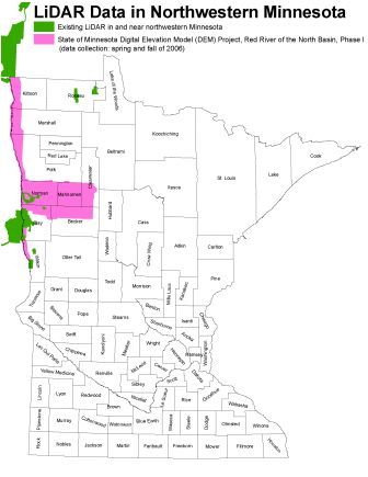
Project description
See an article in the
Summer 2006 GIS/LIS News:
http://www.mngislis.org/associations/6078/files/newsletter/issue45/MN_DEM_Red_River.htm
Update on data status and initial quality assessment
- Article in the Fall 2006 GIS/LIS News:
http://www.mngislis.org/displaycommon.cfm?an=1&subarticlenbr=99 - Reality Check: Processing LiDAR data by Tim Loesch,
Minnesota Department of Natural Resources: This presentation from
the 2006 Minnesota GIS/LIS conference reviews the steps used to process
LIDAR data from the Red River watershed and covers general lessons
learned. Available in:
- PowerPoint slide format (14 MB)
- PDF format (7 MB)
Project files
All the files described below are available for free download at: https://resources.gisdata.mn.gov/pub/data/elevation/red_river_phase1_docs/
- mndem_rfp.doc: Request for Proposals (RFP) scope of work
- mndem_rfp_fig1.pdf: Figure 1 of the RFP scope of work
- mndem_rfp_template.doc: A template for an RFP based on lessons learned during our effort
- mndem_vendorlist.xls: A spreadsheet listing all of the vendors that were sent our RFP via email
- mndem_costoverview.xls: A spreadsheet providing an overview of the cost proposals received
- mndem_contract_exhibita.doc: The scope of work for the final contract
- mndem_contract_exhibita_fig1.pdf: Figure 1 for the contract's scope of work
- lidar_status_nwmn.pdf: Status map showing existing LIDAR data in and near northwestern Minnesota as well as the area covered by the Red River of the North Basin, Phase I
For more information on these files, contact Aaron Buesing at: Aaron.W.Buesing@usace.army.mil or 651-290-5627.