GLO Historic Plat Map
Retrieval System
This site is best viewed on a monitor with a resolution setting of 1024 x 768. It uses code supported by Netscape 4.7 or up and Internet Explorer 5 or up.
|
|
|
|
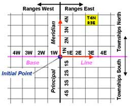
Public Land Survey Townships are named systematically by the township and range numbering system. This system is based on the location of an initial point. Initial points occur at the intersection of a principal meridian and a base line. Each township is named by a township number, which indicates its north-south position of the base line, and a range number, which indicates its east-west position of the principal meridian. |
|
|
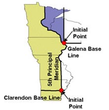
In Minnesota, township numbers east of the Mississippi indicate position north of the Galena Base Line. Township numbers west of the river indicate position north of the Clarendon Base Line. Range numbers indicate position east or west of the 4th Principal Meridian, or west of the 5th Principal Meridian. |
|
|
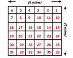
Public Land Survey Townships are subdivided into 36 sections, each section being approximately 1 mile by 1 mile in dimension. Section corners and section-quarter corners were marked by posts or other monuments. Sections are numbered from 1 to 36 and are labeled in a switchback pattern. |
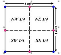 |
Each section can be divided into four quarters: NW, NE, SW, and SE. Each quarter is 160 acres, and these areas too can be subdivided into NW, NE, SW, and SE quarters |
For land located at T43N R20W S6 SW1/4: Township = 43 North of the Base Line, Range = 20 West of the Principal Meridian, Section = 6, and the land constitutes the section’s southwest quarter.Back to History and Origin | |