2025 Governor's Certificates
A Minnesota Governor's Certificate award for exemplary geospatial projects was presented at the Minnesota GIS/LIS Consortium Annual Conference in Duluth, Minnesota on October 3, 2025.
Minnesota Lead Service Line Mapping and Data Display Project
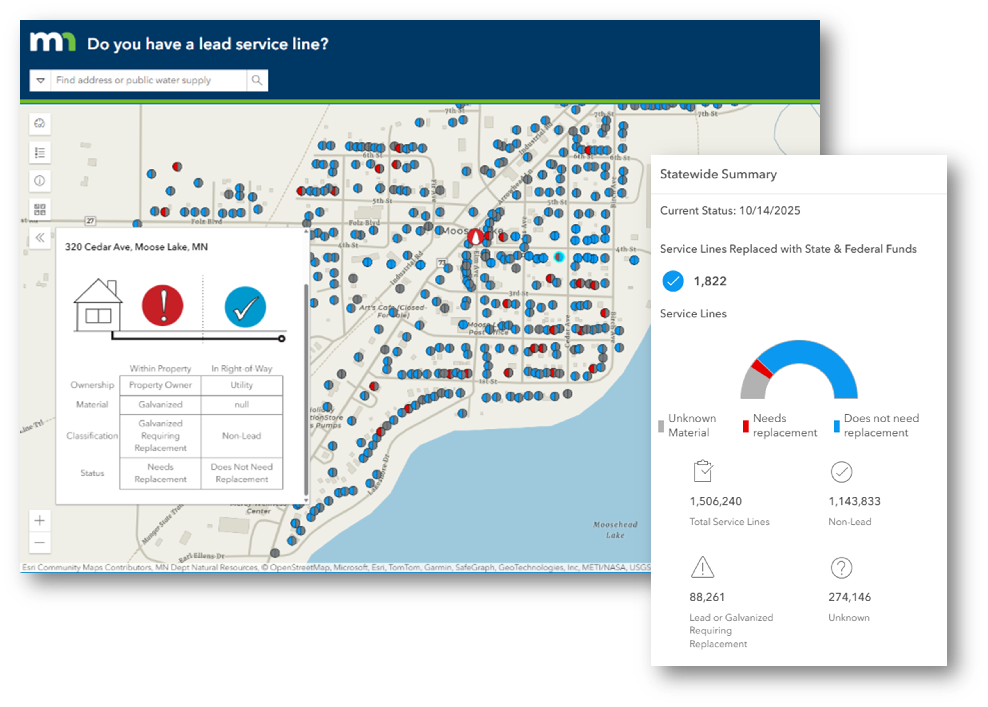 |
Minnesota Lead Drinking Water Service Line Mapping Application
The Minnesota Lead Service Line Mapping and Data Display Project was awarded a Governor's Certificate for its outstanding contribution to public health and geospatial innovation.
Led by the Minnesota Department of Health, this statewide initiative brought together nearly 1,000 public water systems, 18 consulting engineering firms, the Minnesota Rural Water Association, and U-Spatial at the University of Minnesota to identify where drinking water service lines need to be replaced due to risk of lead contamination by service line material. Together, they created a centralized, user-friendly website that allows anyone to search for the type of service line material and potential replacement need at any of the 1.5 million addresses connected to a public water system in Minnesota. The application also summarizes the status of all service lines statewide and within each public water system.
Each water system developed a service line inventory through field visits, record reviews, and investigative techniques, documenting both utility- and customer-owned service lines. Consulting engineering firms and the Minnesota Rural Water Association provided critical support for this effort, especially to smaller water systems. U-Spatial harmonized the data into a single statewide database and built the interactive web map. The resulting tool — with over 100,000 views at the time of the award — has transformed how Minnesota tracks and communicates the status of lead service lines across the state, supporting transparency and informed decision-making.
This large-scale collaboration involved over 2,000 Minnesotans and has empowered residents, parents, and decision-makers with easy access to service line material information. It is exemplary of the importance of collaboration and the efficiency of investing in and sharing geospatial information.
The award was presented to:
- Minnesota Department of Health
- U-Spatial, University of Minnesota
- Minnesota Rural Water Association
Supporting organizations included:
- Consulting engineering companies:
- AE2S
- Apex Engineering Group
- Bollig, Inc.
- Bolton & Menk
- DGR
- ISG
- JPJ Engineering, Inc.
- Karvakko, P.A.
- Moore Engineering, Inc.
- MSA Professional Services, Inc.
- NERO Engineering
- Short Elliott Hendrickson (SEH)
- Stantec Consulting Services, Inc.
- TKDA
- Ulteig Engineers, Inc.
- WHKS & Co.
- Widseth
- WSB & Associates, Inc.
- Public water systems that directly provided geospatial data:
- Albert Lea
- Alexandria
- Apple Valley
- Austin Utilities
- Blaine
- Bloomington
- Brooklyn Center
- Brooklyn Park
- Chanhassen
- Chaska
- Columbia Heights
- Coon Rapids
- Cottage Grove
- Duluth
- Eagan
- Eden Prairie
- Farmington
- Golden Valley
- Hutchinson
- Lakeville
- Maple Grove
- Medina
- Minneapolis
- Minnetonka
- Moorhead
- North Branch
- Norwood-Young America
- Owatonna
- Plymouth
- Prior Lake
- Rochester
- Rosemount
- Saint Cloud
- Saint Louis Park
- Saint Paul Regional Water Services
- Shoreview
- White Bear Lake
For more information, see:
Return to the Awards page