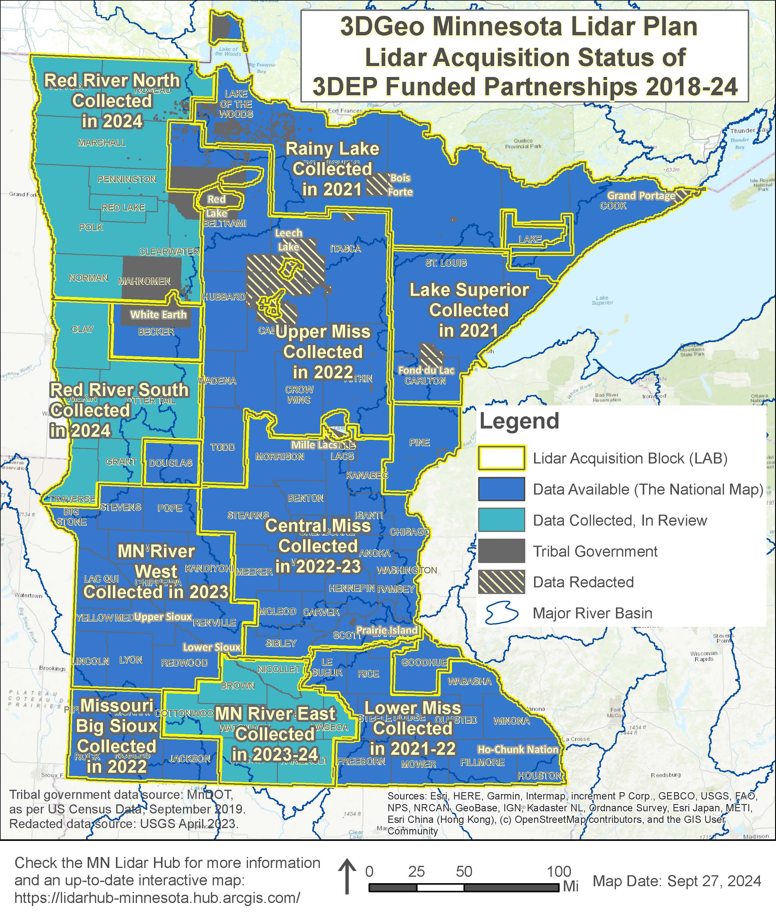
- Lidar Hub site: See the lidar status map and the latest info.
- Minnesota Lidar Plan
- Story Map about the plan
- Frequently Asked Questions (FAQ) about the Lidar plan and 3DGeo efforts
- Current Status of Lidar Planning
- Current Status of Lidar Planning Map
- USGS 3DEP Lidar Areas of Interest - SeaSketch: Express your interests and needs for lidar
- Why 3DGeo Supports Quality Level 1
- Link to USGS Attachment D - Funding Partners Document (complete and email to lidar@state.mn.us). To help with filling out this form, please see: Attachment D FY23 Form Completion Tips
- Sean Vaughn, GIS Hydrologist | Lidar Data Steward, MNIT DNR, 763-689-7100 x226, sean.vaughn@state.mn.us
- Gerry Sjerven, Senior GIS Analyst, Minnesota Power, 218-355-3990, gsjerven@mnpower.com
- Alison Slaats, Director, MnGeo & Chief Geospatial Information Officer, 651-201-3194, alison.slaats@state.mn.us
- Clinton Little, Coastal Program Specialist, Minnesota's Lake Superior Coastal Program, 218-834-1446, clinton.little@state.mn.us
- Lidar-derived Hydrography (LDH) Subgroup
3DGeo Data Acquisition Workgroup

The Data Acquisition Workgroup of the 3D Geomatics Committee promotes acquisition of foundational 3D data for Minnesota. It engages stakeholders, provides guidance and writes standards, defines value and benefits of 3D data, defines management and dissemination needs, bridges disparate lidar procurements with State Plan guided initiatives, and serves as liaison to USGS 3D Nation and USGS 3DEP programs.
Lidar Planning and Informational Materials
Work Plan
Workgroup Membership
Co-chairs
Members
| Name | Organization | |
|---|---|---|
| Matt Baltes | U.S. Department of Agriculture | matthew.baltes@usda.gov |
| Jennifer Corcoran | Minnesota Department of Natural Resources | jennifer.corcoran@state.mn.us |
| Brandon Krumwiede | National Oceanic and Atmospheric Administration | brandon.krumwiede@noaa.gov |
| Colin Lee | Minnesota Department of Transportation | colin.lee@state.mn.us |
| Joel Nelson | University of Minnesota | nels1945@umn.edu |
| Mark Reineke | Widseth | mark.reineke@widseth.com |
| Dan Ross | N/A (individual citizen) | spatial@atthebiglake.net |
| Joe Sapletal | Dakota County | joe.sapletal@co.dakota.mn.us |
| Jeff Weiss | Minnesota Department of Natural Resources | jeff.weiss@state.mn.us |
| Terry Zien | US Army Corps of Engineers | terry.r.zien@usace.army.mil |
Subgroups
- This group is a team of geospatial technologists united as a 3DGeo community of practice that works to bring Next Generation Hydrography (NXG-Hydro) to Minnesota developed from lidar technology.
Return to 3D Geomatics Committee page

