Back to 3DGeo Acquisition Page
3DGeo Data Acquisition Workgroup - Status Information
Statewide Outreach Meeting was held on April 27, 2021. See the slides.
The table below provides an overview of the lidar planning status for the lidar acquisition areas in Minnesota. The rows show different stages of the planning and grant application as well as data acquisition and delivery. The columns and cells show the status for each of the phases by lidar acquisition area. Additionally, the first column provides a guideline for the ideal timeframe for each step, if it is known.
Also please see the Current Status of Lidar Planning Map.
The 3DGeo data acquisition team shares information about upcoming meetings and lidar news in the Minnesota GIS Newsletter. If you have specific questions, or would like to learn more about a specific item on this page, please contact us at lidar@state.mn.us.
| Lidar Acquisition Areas | Northeast Forested | Southwest Agriculture | Southeast Driftless and Missouri Big Sioux |
Metro Area | North Central Lakes | Northwest Red River | |
| Lidar Acquisition Blocks | Rainy Lake Lake Superior |
Minnesota River West Minnesota River East |
Lower Mississippi Missouri Big Sioux |
Central Mississippi River | Upper Mississippi River | Red River North Red River South |
|
| Ideal Timeline | |||||||
| Phase 1 - Planning & Grant Application | |||||||
| Acquisition Area Outreach Meeting |
|||||||
| Initial Meeting Date | Spring | October 21, 2019 |
May 25, 2021 | August 21, 2020 | November 17, 2020 | May 11, 2021 | |
| Additional outreach meetings/materials | Spring/Summer |
2019 NE planning handout
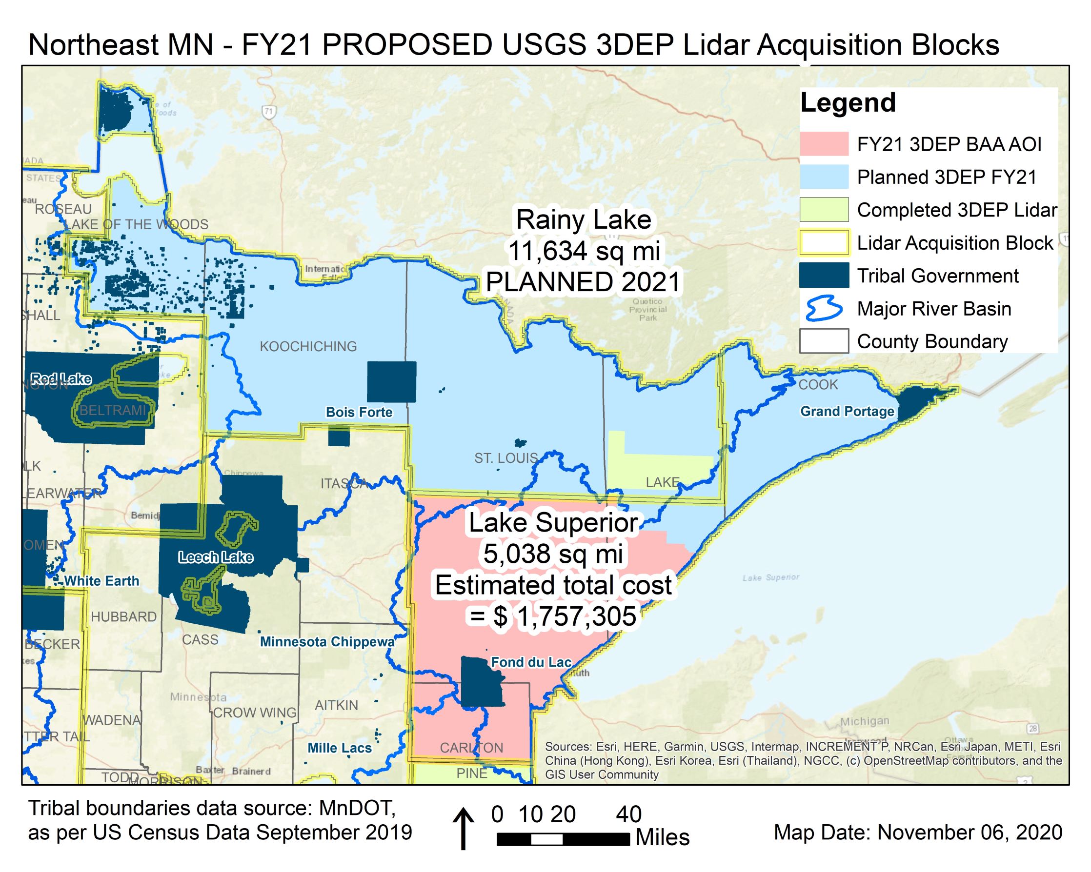
Northeast Lidar Acquisition Area Proposed 2021 Map NE Area Update, July 2020 |
June 15, 2021 Presentation to Stevens Co October 5, 2022 Presentation to Martin, Waseca, and Nicollet counties |
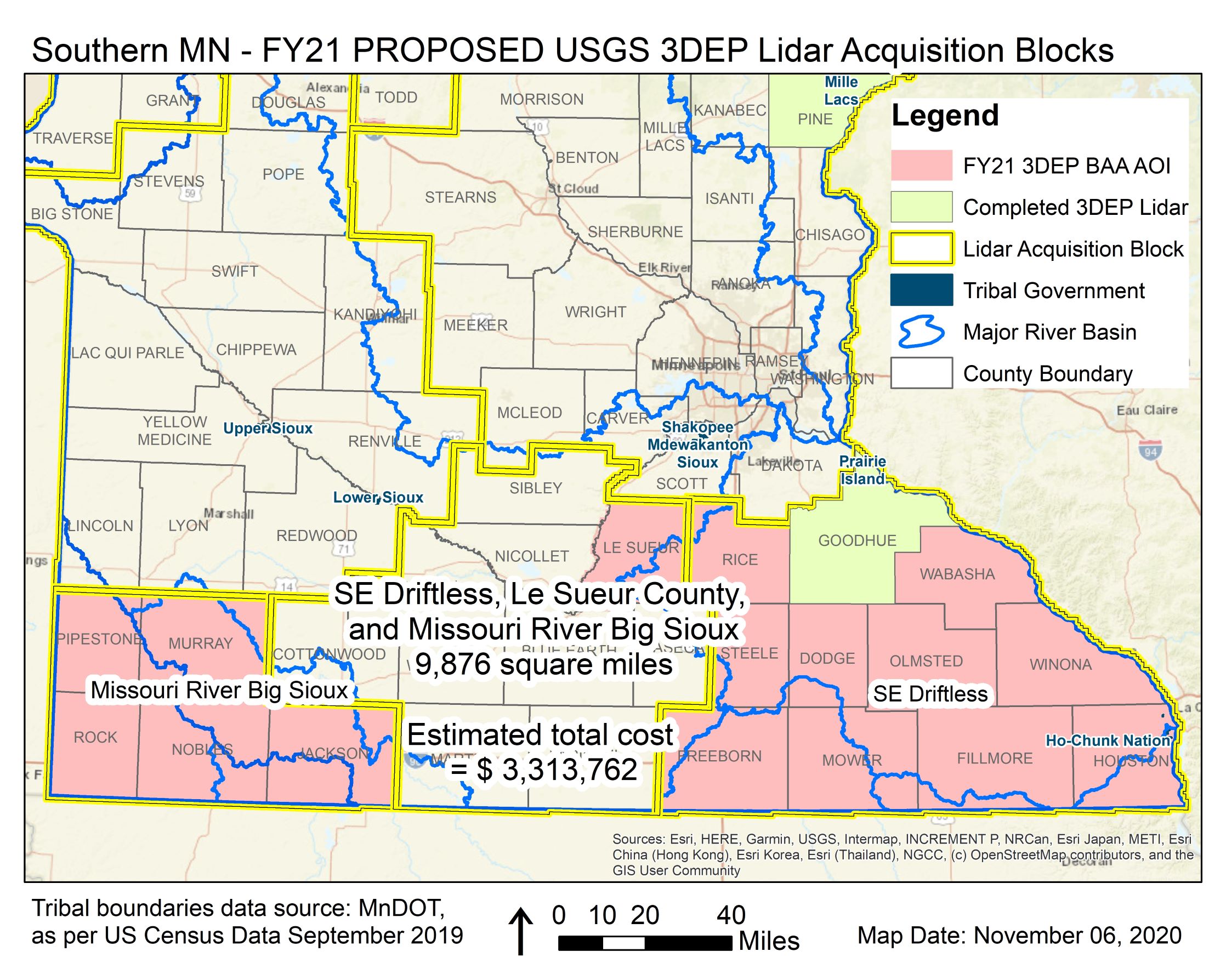
June 16, 2021 Big Missouri Sioux Stakeholder Coordination Meeting October 7, 2020 Funding Southern MN Meeting Southern Minnesota Area 2021 Map |
January 30, 2020 Presentation to Met Council January 11, 2021 Presentation to MetroGIS January 26, 2021 Presentation to Hennepin Co May 20, 2021 Central Region Funding June 7, 2021 Presentation to Anoka Co |
||
| USGS Grant Application & Funding Collaboration Discussion | |||||||
| Meeting Date |
Summer/Fall | September 28, 2020 | August 25, 2022 September 16, 2022 - Meeting with Yellow Medicine, Renville, and Lincoln counties | October 7, 2020 | August 23, 2021 | August 23, 2021 | |
| Feedback Due for BAA |
October | November 6, 2020 |
November 16, 2022 | November 6, 2020 |
September 24, 2021 (Attachment D) | September 24, 2021 (Attachment D) | |
| BAA due |
Mid-November | November 13, 2020 |
November 18, 2022 | November 13, 2020 | October 8, 2021 | October 8, 2021 | |
| BAA Response |
January |
January 2020 (Rainy Lake USGS Funding Recommended) January 2021 (Lake Superior USGS Funding Recommended) |
December 2022 (Minnesota River West and Minnesota River East USGS Funding Recommended) |
January 2021 (Southern Minnesota USGS Funding Recommended) | November 2021 (Central Mississippi River USGS Funding Recommended) |
December 2021 (Upper Mississippi River USGS Funding Recommended) |
|
| Phase 2 - Data Acquisition, Data Delivery to Partners |
|||||||
| JFA & SOW Drafted | February | Complete | In progress | January/February 2022 | January/February 2022 | ||
| JFA & SOW Finalized | March | Complete | Summer 2021 | February 2022 | February 2022 | ||
| Stakeholder provides funds for Task Order |
March | Complete | Summer 2021 | March 2022 | March 2022 | ||
| USGS Task Order issued |
March | Complete | Summer 2021 | March/April 2022 | March/April 2022 | ||
| Field Survey |
March/April |
||||||
| Data Acquisition |
April/May |
April/May 2021 | Anticipated Spring 2023 | Spring 2021 (partial), Spring 2022 (partial) | Spring 2022 (partial) | Spring 2022 | |
| Initial QA/QC |
April/May |
||||||
| Data Calibration & Processing |
|||||||
| Data QA/QC & Distribution |
1 year after acquisition | ||||||
| Phase 3 - Public Distribution of Data and Derivative Products |
|||||||
| Public Data Distribution |
|||||||
Return to 3D Geomatics Committee page