WMS Geospatial Image Service ArcGIS Pro instructions skip to content
    MnGeo logo MnGeo
    MNIT Services printed logo
    • State of Minnesota

    Get IT Help
    Report a problem with your services
    Ask a technical question
    Get IT staff (BUY-IT)

    Find Information
    Services
    Master Contracts (SITE)
    Accessibility

    Order
    IT services
    Phone, Conferencing, WAN (COSWeb)
    Standard Products (BUY-IT)

    Apply for
    Jobs at MNIT
    Vendor opportunities

    Contact MNIT
    General Contacts
    For Vendors

    Primary navigation
    • About MnGeo
      • Organization
      • Annual Report
      • History
      • Data Coordination
      • Technology Coordination
      • GIS Newsletter
      • Jobs
      • Contact us
    • Geospatial Council (GAC)
      • About the Council
      • Committees and Subgroups
        • About
        • 3D Geomatics
          • 3DGeo Executive Steering
          • Data Acquisition
          • Education
          • Hydrogeomorphology
            • DEM Hydro-modification
          • Vegetation
        • Archiving
        • Awards
        • Contributing to Nationwide and Commercial Data Assets
        • Data Endorsement
        • Emergency Preparedness
        • K-12 Education
        • Outreach
        • Parcels and Land Records
        • PLSS Preservation
        • Standards
      • Standards
      • Awards
    • GIS Data and Maps
      • Search
      • Info by Topic
      • Web Map Services
        • How to Use a WMS
        • MnGeo Image Service
        • Composite Image Service
      • Map Gallery
      • Metadata Resources
      • More GIS Data and Maps
    • GIS Consulting
      • MnGeo Consulting
      • Other GIS Consulting
    • Training
      • Training
    • More Resources
      • GIS Contacts
        • County GIS Contacts
        • City GIS Contacts
        • Tribal Government GIS Contacts
      • GIS Organizations
        • MetroGIS
        • GIS/LIS Consortium
        • NSGIC
        • FGDC
      • About Minnesota

    Minnesota Geospatial Image Service: ArcGIS Pro instructions

    Step-by-step instructions for connecting to MnGeo's Geospatial Image Service using Esri's ArcGIS Pro software.
     

    Adding the Service to ArcGIS Pro the first time

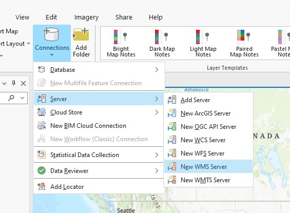
    1. Open ArcGIS Pro and add new WMS Server. Click on the 'Connections' pull-down menu, under the 'Insert' menu. Select 'server' and then 'New WMS Server'

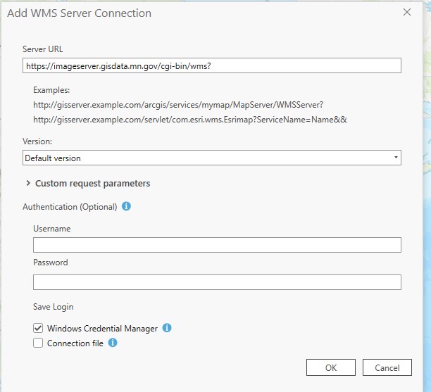
    2. Server URL: https://imageserver.gisdata.mn.gov/cgi-bin/wms?

    3. Leave everything else as defaulted, click 'OK'


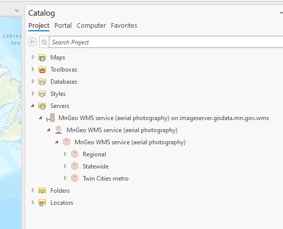
    4. Your project catalog will now have MnGeo's WMS service available. As you open the tree listing, you will note that there are 3 folders: Regional, Statewide and Twin Cities Metro.


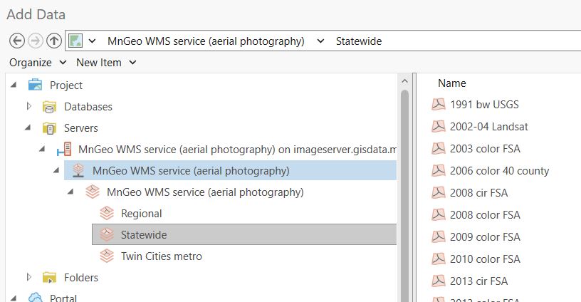
    5. You will find the new imagery in the appropriate folder.


    6.  

      Return to MnGeo's Geospatial Image Service

      Return to MnGeo's WMS homepage


    Footer navigation

    About MnGeo

    • About MnGeo
    • Subscribe to GIS News
    • Contact MnGeo

    About MNIT

    • Accessibility
    • Security
    • Accommodations
    • Affirmative Action Plan
    • Privacy Notice

    For Government

    • Services
    • Procurement
    • Policies and Standards

    Contact MNIT

    • Apply for a job
    • Executive Leadership
    • Contact Other State Agencies

    Connect with MNIT

    mn register to vote
    back to top