Survey about Data Needs for Minnesota LiDAR
MnGeo and the Minnesota Department of Natural Resources assessed better
ways to
provide LiDAR-derived data and information online to the public. A short online
survey helped us understand what formats and delivery
options were most needed. This survey, which closed May 14, 2012,
complemented one conducted the previous
spring that assessed LiDAR training needs.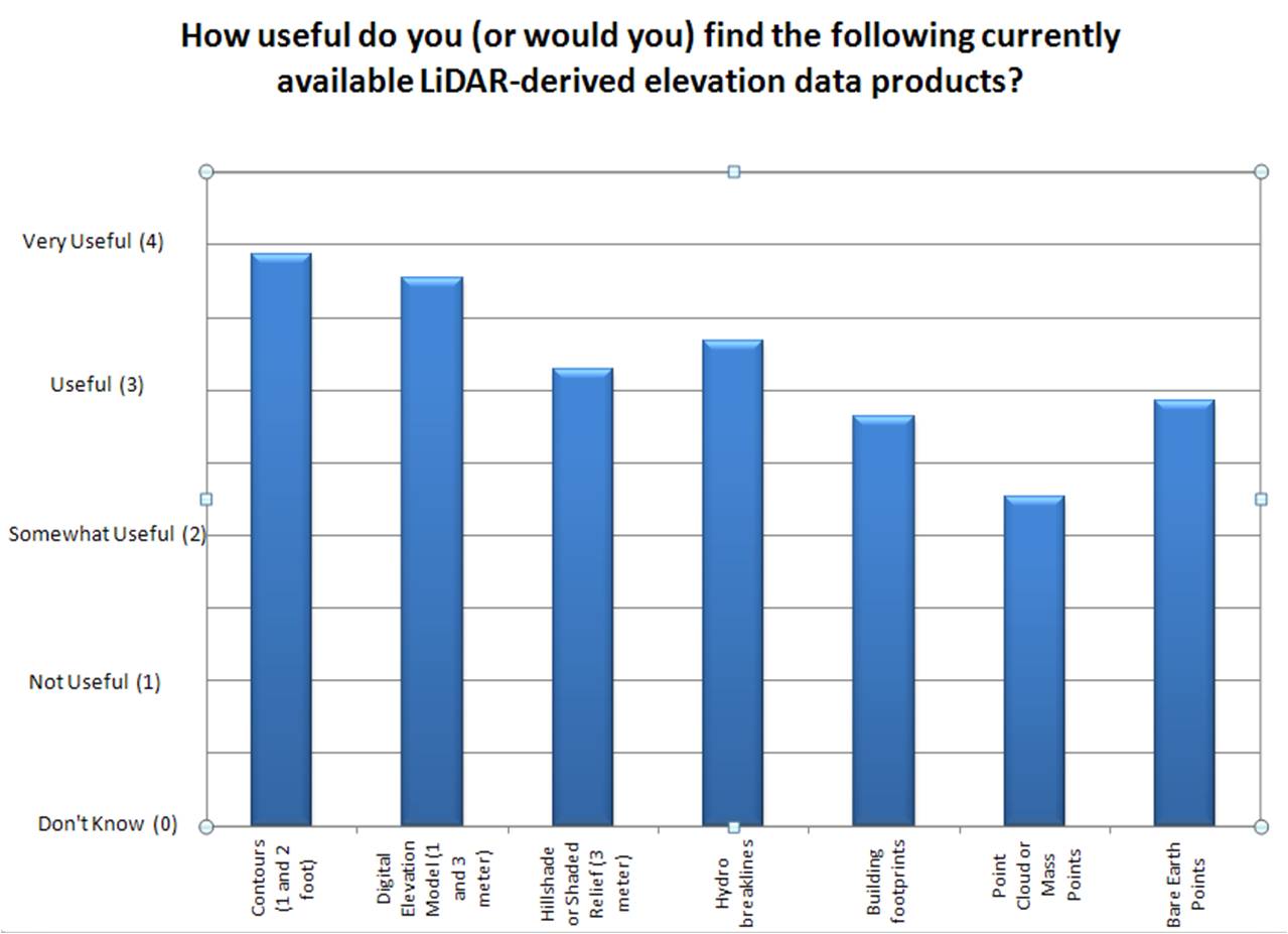
Survey Results
- Questions about the survey? Contact MnGeo, gisinfo.mngeo@state.mn.us
- Related survey on LiDAR training needs done Spring 2011 -- click here for the results.
- For more info about elevation data for Minnesota, including LiDAR, see MnGeo's first-stop elevation info page
Glossary of Terms Used in the Survey
LiDAR
A remote sensing technology that can measure the distance to a target by
illuminating the target with light, using pulses from a laser. The data
points collected by a LiDAR sensor can be converted into a variety of data
products -- e.g., elevation models, contours, hillshade models -- to accurately
describe the topography of the earth and the features on it.
Currently Available LiDAR-Derived Elevation Products
Bare earth points
Points collected by a LiDAR sensor that show the elevation of the ground surface as if there were no
vegetation, buildings, or other man-made structures. (Bare earth points
are a subset of the point cloud data, defined below.)
Building footprints
Polygons that show the outlines of buildings at ground
level.
Contours (1 and 2 foot)
Imaginary lines on the ground, all points of which are at the same elevation.
LiDAR-derived contours for Minnesota are being created at 1 and 2 foot intervals.
Digital Elevation Model (DEM) (1 and 3 meter)
A model of the bare earth surface that has regularly spaced horizontal grid cells,
each with an elevation value. DEMs for Minnesota are being created with 1
and 3 meter grid cells.
Hillshade
or Shaded Relief (3 meter)
Grid cell (raster) data where values have been assigned
to grid cells to mimic the sun's shining on the terrain so that it's easier to see surface relief. Hillshades for
Minnesota are being created with 3 meter resolution.
Hydro breaklines
A breakline is a line
showing a significant change in the smoothness of a
surface such as an abrupt elevation change.
A hydro breakline shows a stream or lake
shoreline.
Point Cloud or Mass Points
Points collected by a LiDAR sensor that show the elevation of the surface of the ground and of objects on
the ground. Point cloud data can be classified into categories (e.g., bare
earth, vegetation, and buildings).
LiDAR Elevation Data Formats and Delivery Service Options
ERDAS IMAGINE
Proprietary format used with
Intergraph’s IMAGINE software for analyzing imagery.
Esri Geodatabase
Proprietary format for data storage used with Esri's ArcGIS and ArcInfo software. A geodatabase represents geographic features and attributes as
objects and is hosted inside a relational database management system.
Esri GRID
Esri's proprietary format for raster (grid cell) data storage. A grid is composed of
equally sized square cells arranged in rows and columns where each cell contains
a value for the feature it covers.
GeoTIFF
A georeferenced TIFF-format image file.
KML (Keyhole Markup Language)
A version of XML used with Google Earth. KML displays geographic data on Google Earth maps and globes.
LAS
A non-proprietary file format used to exchange LiDAR point data. Minnesota's LAS points are classified into categories
(e.g., bare ground, vegetation, and buildings).
Web Map Service (WMS)
A standard way to provide georeferenced map images over the Internet. WMS is
useful for people who just want to view the data, since the images are read-only and cannot be spatially analyzed.
Both raster and vector data can be converted into WMS images.
Web Coverage Service (WCS)
A standard way to provide georeferenced raster grid cells
over the Internet. WCS is useful for people who need content from raster
elevation data since coverages may be edited and spatially analyzed. DEMs
and slope grids are examples of raster data that can be delivered using WCS.
Web Feature Service (WFS)
A standard way to provide georeferenced vector data (points, lines, and
polygons) over the Internet. WFS is useful for people who need content
from vector elevation data, not just images of
the data since WFS may be edited and spatially analyzed. Contour lines, breaklines
and point clouds are examples of vector data that can be delivered using WFS.
Web Application Characteristics
Appearance
Visual appeal of a web application.
Content
Usefulness of the information displayed by a web application.
Functionality
Capabilities of an application seen as the sum of its features.
Usability
Effectiveness, efficiency, and satisfaction with which users can accomplish
their tasks with the web application.