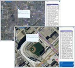
Composite Image Service for Minnesota

MnGeo’s Composite Image Service provides a single layer image service that automatically switches to an appropriate set of air photos or satellite imagery depending on the scale and extent. The images are provided as a WMS (web map service). The primary focus is the Twin Cities Metropolitan Area
and the State of Minnesota. The secondary interest is the areas bordering Minnesota, especially Wisconsin counties close to the metro area.
Imagery is evaluated based on criteria of color, currency, resolution, coverage, season, leaf cover and image quality in order to determine which imagery to include at which scale.
The url for users to paste into their software, or for developers to access the WMS service is:
https://imageserver.gisdata.mn.gov/cgi-bin/mncomp?
The Get Capabilities link for the Composite Service is:
https://imageserver.gisdata.mn.gov/cgi-bin/mncomp?VERSION=1.3.0&SERVICE=WMS&REQUEST=GetCapabilities
- How to use Web Map Services
- Documentation for the Composite Image Service
- Criteria and process for evaluating imagery to be added to the service
-
Interactive Twin Cities Transit Map from Metro Transit, an example of a website that uses the Composite Image Service
Imagery Visible at Different Scales
The layers higher in the list will show through in areas not covered by layers further down. For example, Landsat will continue to be displayed across bordering states where the FSA NAIP data does not extend.
| Scale | Title | Layer Name (from Geospatial Image Service) |
Geographic Area | Year | Season | Resolution | Metadata |
| 1:250,000 and above | Landsat | landsat | Minnesota plus 100-200 miles into adjoining states and Canada | 1999-2002 | Varies | 30-meter | |
| <1:250,000 | FSA NAIP | fsa2023 | Minnesota | 2023 | Summer | 0.3-meter | |
| FSA NAIP | fsa2008 | western Wisconsin counties | 2008 | Summer | 1-meter |
Return to MnGeo's WMS homepage

