Minnesota Geospatial Image Service: Data Layers
Newest Layers
Dates in parentheses indicate the month and year the imagery was added to the service.
- 2025 FSA NAIP imagery (April 2026)
- 2025 Twin Cities Metro imagery (December 2025)
- 2025 Wabasha County imagery (September 2025)
- 2023 Beltrami County imagery (September 2025)
- 2018 McLeod County imagery (September 2025)
MnGeo’s Geospatial Image Service provides access to the following data layers:
1. Digital orthophotography
| Layer Name | Geographic Area | Season | Originator* | Type** | Resolution | Metadata | WMS Layer Name | Notes | Status*** |
| Statewide | |||||||||
|---|---|---|---|---|---|---|---|---|---|
| 2025 FSA | Statewide | summer | FSA | nc / cir | 0.6-meter (approx. 2-foot) |
|
fsa2025 / fsa2025cir | active | |
| 2023 FSA | Statewide | summer | FSA | nc / cir | 0.3-meter (approx. 1-foot) |
|
fsa2023 / fsa2023cir | active | |
| 2021 FSA | Statewide | summer - fall | FSA | nc / cir | 0.6-meter (approx. 2-foot) |
|
fsa2021 / fsa2021cir | active | |
| 2019 FSA | Statewide | summer - fall | FSA | nc / cir | 0.6-meter (approx. 2-foot) |
|
fsa2019 / fsa2019cir | active | |
| 2017 FSA | Statewide | summer - fall | FSA | nc / cir | 1-meter |
|
fsa2017 / fsa2017cir | Noticeable color variation between imagery captured during growing season and after harvest. | active |
| 2015 FSA | Statewide | summer | FSA | nc / cir | 1-meter |
|
fsa2015 / fsa2015cir | Noticeable color variation between imagery captured during growing season and after harvest. | active |
| 2013 FSA | Statewide | summer | FSA | nc / cir | 1-meter |
|
fsa2013 / fsa2013cir | active | |
| 2010 FSA | Statewide | summer | FSA | nc | 1-meter |
|
fsa2010 | active | |
| 2009 FSA | Statewide | summer | FSA | nc | 1-meter |
|
fsa2009 | active | |
| 2008 FSA | Statewide | summer | FSA | nc / cir | 1-meter |
|
fsa2008 / cir2008 | active | |
| 2006 40-county | 40 counties (map) | summer - fall | MDA | nc | 1-meter |
|
usgs2006 | USGS procured photos from MDA for public distribution. | active |
| 2003 FSA | Statewide | summer | FSA | nc | 1-meter |
|
fsa | Most imagery is from 2003; missing areas were filled 2004. | active |
| 2002-04 Landsat | Statewide and beyond | varies | USGS | nc | 30-meter |
|
landsat | Includes 100-200 miles into adjoining states and Canada | active |
| 1991 USGS | Statewide | spring | USGS | bw | 1-meter |
|
doq | To display in ArcGIS Pro, use version 2.5 or above | active |
| Hillshade (lidar) | Statewide | varies | DNR; MnGeo; partners | bw | 1-meter |
|
hillshd | To display in ArcGIS Pro, use version 2.5 or above | active |
| Twin Cities Metro | |||||||||
| 2025 7-county | Twin Cities | spring | Met Council | nc / cir | 1-foot | met25 / met25cir | Anoka, Carver, Dakota, Hennepin, Ramsey, Scott, and Washington counties | active | |
| 2023 Dakota 6 in | Dakota Co. | spring | Dakota Co. | nc | 6-inch | dak23 | active | ||
| 2022 Hennepin 6 in | Hennepin Co. | spring | Hennepin Co. | nc | 6-inch | hen22 | active | ||
| 2021 Hennepin 6 in | Hennepin Co. | spring | Hennepin Co. | nc | 6-inch | hen21 | active | ||
| 2021 Dakota 6 in | Dakota Co. | spring | Dakota Co. | nc | 6-inch | dak21 | active | ||
| 2020 Ramsey 6 in | Ramsey Co. | spring | Ramsey Co. | nc / cir | 6-inch | rams20 / rams20cir | active | ||
| 2020 7-county | Twin Cities | spring | Met Council | nc / cir | 1-foot |
|
met20 / met20cir | Anoka, Carver, Dakota, Hennepin, Ramsey, Scott, and Washington counties. | active |
| 2019 Dakota 6 in | Dakota Co. | spring | Dakota Co. | nc / cir | 6-inch |
|
dak19 / dak19cir | active | |
| 2018 Hennepin 3 in | Hennepin Co. | spring | Hennepin Co. | nc | 3-inch |
|
hen18 | active | |
| 2016 7-county | Twin Cities | spring | Met Council | nc / cir | 1-foot |
|
met16 / met16cir | Anoka, Carver, Dakota, Hennepin, Ramsey, Scott, and Washington counties | active |
| 2013 Washington | Washington Co. | spring | Washington Co. | nc | 0.15-meter (6-inch) |
|
wash13 | active | |
| 2013 Scott | Scott Co. | spring | Scott Co. | nc / cir | 0.15 meter (6-inch) |
|
scott13 / scott13cir | nc: active cir: inactive |
|
| 2013 Dakota | Dakota Co. | spring | Dakota Co. | nc / cir | 0.15 meter (6-inch) |
|
dak13 / 2013 cir Dakota | inactive | |
| 2013 Carver | Carver Co. | spring | Carver Co. | nc / cir | 0.15 meter (6-inch) |
|
2013 color Carver / carv13cir | inactive | |
| 2012 Twin Cities | Twin Cities | spring | USGS | nc | 0.3-meter |
|
nga2012 | Minneapolis - St. Paul area | active |
| 2010 Scott | Scott Co. | spring | Scott Co.; partners | nc / cir | 0.15 meter (6-inch) | scott10 / scott10cir | nc: active cir: inactive |
||
| 2010 north counties | north of Twin Cities | spring | DNR; Met Council; USGS/NGA | nc / cir | 0.5-meter |
|
smet10 / smet10cir | Chisago, Isanti, Sherburne, & Wright counties | active |
| 2010 Dakota | Dakota Co. | spring | Dakota Co.; partners | nc / cir | 0.15 meter (6-inch) | dak10 / dak10cir | inactive | ||
| 2010 7-county | Twin Cities | spring | DNR; Met Council; USGS/NGA | nc / cir | 1-foot |
|
met10 / met10cir | Anoka, Carver, Dakota, Hennepin, Ramsey, Scott, and Washington counties. | active |
| 2008 Twin Cities | Twin Cities | spring | USGS | nc | 0.3-meter |
|
nga2008 | Minneapolis - St. Paul downtown area | inactive |
| 2006 Ramsey | Ramsey Co. | spring | USGS | nc | 0.15-meter (6-inch) |
|
stp2006 | active | |
| 2006 7-county (partial) | Twin Cities | spring | USGS | nc | 0.3-meter |
|
msp2006 | Minneapolis - St. Paul area | active |
| 2004 MSP | Twin Cities | spring | NGA; USGS | nc | 0.3-meter |
|
metro | Minneapolis - St. Paul downtown areas | active |
| 2000 7-county | Twin Cities | spring | Met Council | bw | 0.6-meter |
|
bw2000 | 7-county Twin Cities. To display in ArcGIS Pro, use version 2.5 or above. | active |
| 1997 7-county | Twin Cities | spring | Met Council | bw | 0.6-meter |
|
bw1997 | 7-county Twin Cities. To display in ArcGIS Pro, use version 2.5 or above. | active |
| Regional | |||||||||
| 2025 Wabasha 2 in | Wabasha Co. | spring | Wabasha Co. | nc | 2-inch | wab25 | active | ||
| 2024 Lake 6 in | Lake Co. | spring | Lake Co. | nc | 6-inch | lake24 | active | ||
| 2023 Beltrami 9 in | Beltrami Co. | spring | Beltrami Co. | nc | 9-inch | belt23 | active | ||
| 2023 Rice 6 in | Rice Co. | spring | Rice Co. | nc | 6-inch | rice23 | active | ||
| 2022 Douglas 2 in | Douglas Co. | spring | Douglas Co. | nc | 2-inch | doug22 | active | ||
| 2022 McLeod 4 in | McLeod Co. | spring | McLeod Co. | nc | 4-inch | mcle22 | active | ||
| 2022 Steele 3 in | Steele Co. | spring | Steele Co. | nc | 3-inch | steele22 | active | ||
| 2021 Carlton 6 in | Carlton Co. | spring | Carlton Co. | nc | 6-inch | carlton21 | active | ||
| 2021 Le Sueur 3 in | Le Sueur Co. | spring | Le Sueur Co. | nc | 3-inch | lesueur21 | active | ||
| 2021 Rice 6 in | Rice Co. | spring | Rice Co. | nc | 6-inch | rice21 | active | ||
| 2020 Beltrami 9 in | See notes | spring | Beltrami Co. | nc / cir | 9-inch |
|
belt20 / belt20cir | Does not cover Red Lake Nation or far northern areas of county | active |
| 2020 Koochiching 1 ft | Koochiching Co. | spring | Koochiching Co. | nc | 1-foot |
|
kooc20 | active | |
| 2020 Lyon 3 in | Lyon Co. | spring | Lyon Co. | nc | 3-inch | lyon20 | active | ||
| 2019 Carlton 6 in | Carlton Co. | spring | Carlton Co. | nc / cir | 6-inch | carl19 / carl19cir | active | ||
| 2019 Lake 6 in | Lake Co. | spring | Lake Co. | nc | 6-inch | lake19 | active | ||
| 2019 Steele 6 in | Steele Co. | spring | Steele Co. | nc | 6-inch | steele19 | active | ||
| 2018 Itasca 1 ft | Itasca Co. | spring | Itasca Co. | nc / cir | 1-foot | itas18 / itas18cir | active | ||
| 2018 McLeod 4 in | McLeod Co. | spring | McLeod Co. | nc | 4-inch | mcle18 | active | ||
| 2016 Douglas 3 in | Douglas Co. | spring | Douglas Co. | nc | 0.075-meter (3-inch) |
|
doug16 | active | |
| 2015 Carlton 9 in | Carlton Co. | spring | Carlton Co. | nc | 9-inch |
|
carl15_9 | active | |
| 2014 NW 50 cm | See notes | spring | DNR | nc / cir | 0.5-meter |
|
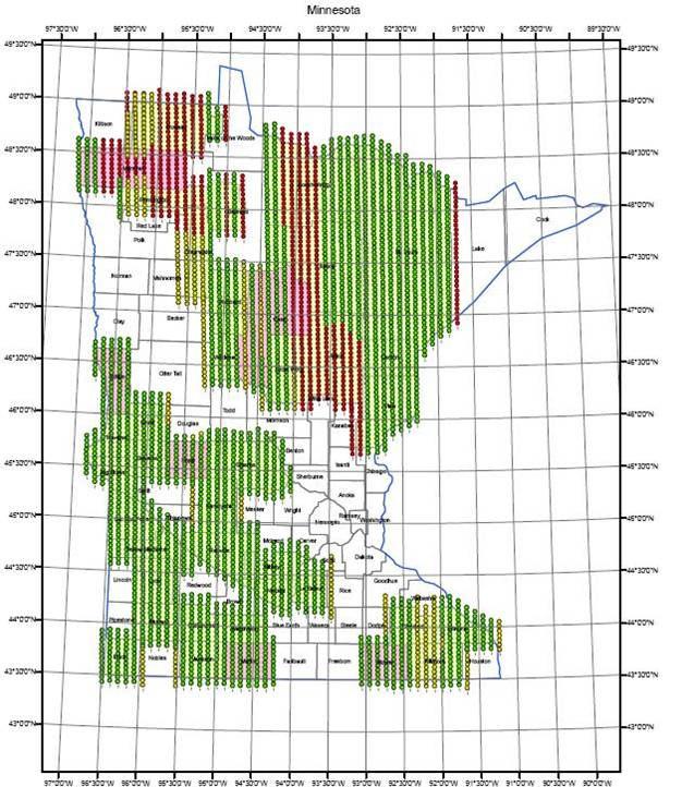
nw14 / nw14cir | 3 swaths across northwest and north-central Minnesota (see tan areas on upper map) | active |
| 2014 Polk Beltrami 1 ft | Polk, Beltrami counties | spring | DNR | nc / cir | 1-foot |
|
polk / polkcir | active | |
| 2014 McLeod | McLeod Co. | spring | McLeod Co. | nc / cir | 0.15-meter (6-inch) |
|
mc14 / mc14ir | nc: active cir: inactive |
|
| 2013 NW 50 cm | See notes | spring | DNR | nc / cir | 0.5-meter |
|
nc13hm / nc13hmcir | 3 swaths across northwest and north-central Minnesota (see green areas on upper map) | active |
| 2013 North 1 ft | See notes | spring | DNR | nc / cir | 1-foot |
|
nc13ft / nc13ftcir | Carlton, Clay, Itasca, Mille Lacs, and Wilkin counties; Fond du Lac and White Earth reservations; Camp Ripley (see map) | active |
| 2013 Meeker | Meeker Co. | spring | DNR | nc / cir | 0.5-meter |
|
meek13 / meek13cir | Originally scheduled for 2011; flown 2013. | nc: active cir: inactive |
| 2012 fall central | 7 counties (2 partial) in Central MN | fall | DNR | nc / cir | 0.5-meter |
|
fall12 / fallcir12 | Becker (eastern), Cass, Clearwater (southern), Crow Wing, Hubbard, Mahnomen and Wadena counties. | active |
| 2011 fall EC, SE | 16 counties in east central and SE MN | fall | DNR | nc / cir | 0.5-meter |
|
fall11 / fallcir11 | EC: Aitkin, Anoka, Benton, Carlton,
Chisago, Isanti, Kanabec, Mille Lacs, Pine, Sherburne, plus northern
Washington and Ramsey counties. SE: Fillmore, Goodhue, Houston, Olmsted, Wabasha and Winona counties. |
active |
| 2011 south MN | 37 counties in south MN | spring | DNR; partners | nc / cir | 0.5-meter |
|
south11 / south11ir | Big Stone, Blue Earth, Brown, Chippewa, Cottonwood, Dodge, Faribault, Fillmore, Freeborn, Goodhue, Houston, Jackson, Kandiyohi, Lac qui Parle, Le Sueur, Lincoln, Lyon, Martin, McLeod, Mower, Murray, Nicollet, Nobles, Olmsted, Pipestone, Redwood, Renville, Rice, Rock, Sibley, Steele, Swift, Wabasha, Waseca, Watonwan, Winona and Yellow Medicine counties. | active |
| 2011 Murray | Murray Co. | spring | Murray Co.; partners | nc / cir | 1-foot | murray11 / murray11ir | nc: active cir: inactive |
||
| 2011 Rice | Rice Co. | spring | Rice Co.; partners | nc / cir | 1-foot | rice11 / rice11cir | nc: active cir: inactive |
||
| 2009 south shore (WI) | Wisconsin lakeshore | summer | USGS | nc | 0.3-meter | wisc09 | Part of Lake Superior shore of Wisconsin, including Apostle Islands | nc: active cir: inactive |
|
| 2009 nw border | Northern border | summer | USGS | nc | 0.3-meter |
|
ndak09 | Includes most of Kittson and western Roseau counties (MN), Pembina County (ND), and parts of southern Manitoba, Canada | inactive |
| 2009 north shore | Superior lakeshore | summer | USGS | nc | 0.3-meter | sbay09 | Lake Superior shore in St. Louis and SE Cook counties | active | |
| 2009 NCentral border | Northern border | summer | USGS | nc | 0.3-meter |
|
bord15 | Includes east Roseau, most of Lake of the Woods, northern Koochiching, and NW St. Louis counties (MN) and southern Manitoba and Ontario, Canada | active |
| 2009 NCentral | North-central MN | spring | DNR; partners | nc / cir | 0.3-meter |
|
ncclr09 / ncir09 | Big Fork and Little Fork watersheds (most of Koochiching, northern Itasca, and central St. Louis counties). | active |
| 2009 Isle Royale | Isle Royale | summer | USGS | nc | 0.3-meter | iroy09 | NE Cook County, Isle Royale, and southern Ontario, Canada | active | |
| 2009 Duluth shore | Duluth lakeshore | summer | USGS | nc | 0.3-meter | dul09 | Lake Superior shore near Duluth, mostly St. Louis Co. (MN) and Douglas Co. (WI) | active | |
| 2009 Duluth | Duluth area | spring | DNR; partners | nc / cir | 0.3-meter |
|
dulclr09 / dulir09 | Area around the city of Duluth | active |
| 2009 BWCA border | Boundary Waters area | summer | USGS | nc | 0.3-meter | bwca09 | Includes much of the Boundary Waters Canoe Area Wilderness, NE St. Louis, northern Lake and Cook counties, and southern Ontario, Canada | active | |
| 2009 Arrowhead | NE MN | spring | DNR; partners | nc / cir | 0.5-meter |
|
neclr2009 / neir2009 | Carlton, Cook, Lake, and St. Louis counties | active |
| 2008-09 Red River | Portions of the Red River Basin | spring | International Water Institute | nc | 0.5-meter |
|
rr2009 | Parts of counties along the Red River, both western MN and eastern North Dakota. | active |
If you have imagery that you would like to suggest or contribute, or you would like to participate in the committee that evaluates future additions, contact the Image Service Sustainability Committee.
* Originator:
Census = U.S. Census Bureau
DNR = Minnesota Department of Natural Resources
FSA = Farm Service Agency, U.S. Department of Agriculture
MDA = MDA Geospatial Services, Inc.
Met Council = The Metropolitan Council of the Twin Cities
NGA = National Geospatial-Intelligence Agency
USGS = United States Geological Survey
** Type:
nc = natural color (red, green and blue bands)
cir = color infrared (near infrared, red and green bands)
bw = black and white
*** Status:
Active: The most frequently used layers in the service. They are available to all users all the time.
Retirement candidate: These layers have fallen below the threshold required to be considered active but continue to be available in the service. After one year, a candidate layer will transition to an inactive layer.
Inactive: These layers are no longer available in the service. However, if a sponsor comes forward, the layer can be reactivated to the service. (There are no inactive layers at present.)
For more information, see the Sustainability Plan Proposal from the Image Service Sustainability Committee.
2. Scanned USGS topographic quadrangle maps (Digital Raster Graphics – DRGs)
- Statewide 1:24,000-scale, 2.4-meter resolution
- Statewide 1:100,000-scale, 10.0-meter resolution
- Statewide 1:250,000-scale, 25.4-meter resolution
Return to Geospatial Image Service homepage