MN Mapper Help
Design your map
Print or save your map
Question/Answer
Disclaimer
Contact Us
Step 1: Design Your Map
Add themes
Click in the box to the left of the themes you want to draw on your map
(under the word "Visible").
Click the Refresh Map button.
The Legend will show you the symbol used for each theme.
Add labels
Click in the box to the right of the themes you want labeled
(under the word "Label").
(Note: you cannot display labels for a theme that is not visible).
Click the Refresh Map button.
Remove themes and labels
Click in the boxes to remove the check mark beside the themes and/or labels you
want to remove.
Click the Refresh Map button.
General hint
It's a good idea to keep your map as simple as you can. The
labels have been arranged so that they don't overlap even if you show all
of the possible themes and labels, but the map could look cluttered.
Step 2: Print or Save Your Map
First, make sure your browser's Pop-up Blockers are turned off!
Print map
Click the Continue... button.
![]()
Type in a title for your map (or delete the default title,
Minnesota,
and leave it blank).
Click the Get Printable Map button.
Choose Print from the
File menu
on your Internet browser's toolbar.
Close this print window to return to the main MN Mapper window.
(Note: the printout will include the title and legend and is designed
to fit on an 8 1/2" x 11" page using quarter-inch margins. Check your
margins by choosing Page Setup...
from the
File menu; if necessary, change
margins to 0.25 inches.)
Save map
Click the Continue... button.
![]()
Type in a title for your map (or delete the default title,
Minnesota,
and leave it blank).
Click the Get Printable Map button.
Click anywhere on the map with the right button on your mouse
("right-click")
Choose Save Picture As...
(Internet Explorer) or
Save Image As... (Netscape) from the popup
menu.
Choose the folder on your computer where you want to save your map.
Rename the file if you like.
Choose a format (PNG or BMP in Internet Explorer 6; PNG in Netscape 6) that you can use with other software that you have.
To save the legend: right-click on it and repeat the procedure you
used to save the map.
Close this print window to return to the main MN Mapper window.
Question/Answer
- How can I prevent my
printed map
from getting cut off at the
edges?
MN Mapper fills the print page to quarter-inch margins on all sides. If your map is getting cut off, choose Page Setup... from the File menu on your browser's toolbar to change the print margins to 0.25 inches.
- The lines and text look broken up on the
Printable Map screen.
Why is that and will my print look like that too?
Computer screens can't show as much detail as printers can, so the lines and text may not show clearly. The printed map should look fine.
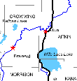
Sample of broken lines and text on screen display
- I click the "Continue" button,
but I don't see a Print Window, and the map I made resets to a blank.
How do I fix this?
Check to make sure your browser's Pop-up Blocker is turned off. In Internet Explorer, look under the Tools menu, and check the settings for Pop-up Blocker. In Firefox, look under the Tools menu, choose Options and then look in the Content section.
- Can I zoom in closer?
No. This site was designed to produce simple, page-sized state maps.
The NorthStar Mapper website will allow you to zoom in closer to see many additional types of information such as air photos and topographic maps.
- How did you choose which roads, rivers and lakes
to display?
On a page-size state map, only the largest features can be shown. We chose the following:
Roads: all interstates and U.S. highways (source: Minnesota Department of Transportation)
Rivers: the 15 longest rivers (source: U.S. Geological Survey)
Lakes: the 20 largest lakes (source: U.S. Geological Survey)
- Will more themes be added in the future?
A firm maybe. Let us know if there are any themes you would like to see added.
Disclaimer
MN Mapper maps are informational only. They are provided as is without any warranty whatsoever. See the full text of MnGeo's disclaimer.
Contact Us
Questions? Suggestions? Email: gisinfo.mngeo@state.mn.us, call Jim Dickerson at (651) 201-2484 or write to the Minnesota Geospatial Information Office, 658 Cedar Street, Room 300, St. Paul, MN 55155.