Minnesota Land Use/Cover: Historic
Land Use/Cover Home
| Quick Start |
Recent Data |
Historic Data |
Classification Systems
This page describes land use/cover data and maps from the mid-1800s, as recorded at the time of European settlement, as well as earlier reconstructions from fossil pollen records.
 |
|
|
|
- General Land Office (GLO) records: Surveyors laying out Minnesota's public land survey system in 1848-1907 recorded the
size and species of the larger trees they used as markers (bearing trees),
as well as general descriptions of the physical geography of the landscape
they traversed. Although not a complete vegetation survey, the General
Land Office records provide much valuable detail about how the state
looked at the time of European settlement.
- Scanned GLO maps and field notes from MnGeo. View or download.
- Bearing tree records: GIS data from the Minnesota Department of Natural Resources
-
Minnesota's Bearing Tree Database documentation (PDF, 185K)
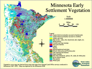
- Map of the Original Vegetation of Minnesota ("Marschner's
Map"):
Francis J. Marschner interpreted the notes from the General Land Office records to create a large state map showing how Minnesota looked at the time of European settlement.
- Article: The Mystery of a Map and a Man. The intriguing story about Marschner and the creation of his map, by Tim Brady, from DNR's Minnesota Conservation Volunteer magazine (Jan.-Feb. 2003 issue)
- Prints or scans of the original map: Available for purchase in a choice of sizes (printed) and resolutions (scans) from the Minnesota Historical Society.
-
Maps:*
created by the U.S. Forest Service, North Central
Experiment Station, from DNR's digitized version of Marschner's map. Maps are available for Minnesota, Wisconsin and Michigan
and for the Northern Great Lakes Ecoregions.
- GIS data: from DNR
-
Publication: Natural Vegetation of Minnesota at the Time of the Public Land Survey,
1847-1907, 6-pages, available from DNR's Ecological
Services Division.
*links to these resources will be added once available
-
Reports of Estimates and Appraisals of the Timber Commissions Board,
1895-1905: Surveys of state-owned timber were conducted on a
number of public land survey sections scattered throughout the forested
northern half of Minnesota. The maps and notes include information about
timber species and volumes. Available in three formats:
scanned images,
vector files, and
database files.
-
Potentially Undisturbed Land (Virgin Sod), derived from FSA
Common Land Unit data
- Minnesota portion, Prairie Coteau and Lac qui Parle landscapes in western and southwestern MN
-
South Dakota portion, eastern SD
Long-term change and potential natural vegetation
-
Perspectives on the Land Use History of North America: A context for understanding our changing environment
(full article): U.S. Geological Survey,
Biological Resources Division, 1998.
See the sections on "Great Lakes Landscape Change" and "Upper Mississippi River Vegetation." The Great Lakes Landscape Change section draws on data from three main sources (the fossil pollen record, Government Land Office surveys and the U.S. Forest Service's Fourth Forest Inventory) to assess changes during two time periods:- Between 1,000 years ago and presettlement
- Between presettlement and the present.
- LANDFIRE: U.S. Department of Agriculture Forest Service
and U.S. Department of the Interior
This multi-partner program produces consistent, comprehensive, geospatial data and databases that describe vegetation, wildland fuel, and fire regimes.-
Potential vegetation layers: Biophysical settings, along with
models and descriptions, and environmental site potential
-
Potential vegetation layers: Biophysical settings, along with
models and descriptions, and environmental site potential
-
Potential Natural Vegetation, A.W. Kuchler, 1960s (Kuchler, A.W. 1964. Potential Natural Vegetation of the Conterminous United States. American Geographical Society, Special Publication No. 36)
Kuchler's classification indicates the types of vegetation that would likely cover the land if there were no disturbances from people or nature.
Return to MnGeo's main Land Use/Cover page
Back to top