3D Geomatics Committee
The 3D Geomatics* Committee (3DGeo) of the Minnesota Geospatial Advisory Council works to identify and promote the need for planning, funding, acquisition, and management of three-dimensional geomatic data and derived products. The committee engages multiple disciplines in Minnesota for the benefit of its resources and citizens, promoting the value, importance, and use of this complex and voluminous three-dimensional information.
* Geomatics: the discipline of gathering, storing, processing, and delivering spatially referenced geographic information
What's New
- See lidar status map and the latest info on the new Lidar Hub site.
- Updated Minnesota Lidar Plan
- Schedule a meeting with the Acquisition Team by emailing lidar@state.mn.us
Charter and Work Plan
Committee Organization
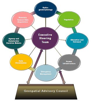
The committee is coordinated by an executive steering team. The steering team serves as the hub for the subject-matter workgroups shown in the graphic.
Executive Steering Team
- Co-chairs
- Sean Vaughn, GIS Hydrologist | Lidar Data Steward, MNIT DNR, 763-689-7100 x226, sean.vaughn@state.mn.us
- Gerry Sjerven, Senior GIS Analyst, Minnesota Power, 218-355-3990, gsjerven@mnpower.com
Workgroups
Data Acquisition Workgroup
- Champions
- Sean Vaughn, GIS Hydrologist | Lidar Data Steward, MNIT DNR, 763-689-7100 x226, sean.vaughn@state.mn.us
- Gerry Sjerven, Senior GIS Analyst, Minnesota Power, 218-355-3990, gsjerven@mnpower.com
- Alison Slaats, Program Manager, MnGeo, 651-201-3194, alison.slaats@state.mn.us
- Clinton Little, Coastal Program Specialist, Minnesota's Lake Superior Coastal Program, 218-834-1446, clinton.little@state.mn.us
Education Workgroup
- Champion
- Joel Nelson, GIS Specialist, University of Minnesota, Dept. of Soil, Water and Climate, 612-625-9235, nels1945@umn.edu
- Joel Nelson, GIS Specialist, University of Minnesota, Dept. of Soil, Water and Climate, 612-625-9235, nels1945@umn.edu
Hydrogeomorphology Workgroup
- Co-chairs
- Andrea Bergman, GIS Hydrologist, MNIT DNR, 651-259-5690, andrea.bergman@state.mn.us
- Rick Moore, Lidar Data Steward, MNIT DNR, 507-389-8810, rick.moore@state.mn.us
- Jamie Schulz, GIS Specialist, MNIT DNR, 507-206-2830, jamie.schulz@state.mn.us
Vegetation Workgroup
- Champion
- Luke Spaete, Research Analysis Specialist Sr, DNR Division of Forestry, Resource Assessment, 218-322-2506, lucas.spaete@state.mn.us
- Chair
- Jennifer Corcoran, Remote Sensing Program Consultant, DNR Division of Forestry, Resource Assessment, 651-259-5898, jennifer.corcoran@state.mn.us
Other workgroups are forming...
Resources
- Initial groundwork for this committee (Nov. 4, 2015): minutes and slides
- Minnesota State Lidar Plan created by the Data Acquisition Workgroup
- MnTOPO: A web application for viewing, printing and downloading high-resolution elevation data for Minnesota collected using lidar technology
- Lidar info and download page for Minnesota lidar data and derived products, including links to education and training resources
- Interim Guidance on Acquisition of Culvert Data
- Hydrographic Position Index Technical Report: Combining lidar-derived DEM analysis, raster classification and color symbology for pseudo-3D terrain visualization to enhance hydrography interpretation on the DEM landscape
- Glossary of lidar-related Terms
- 2008 National Environmental Information Exchange Network (NEIEN) Project Report, June 2014: This report
explored integrating the multiple statewide hydrography datasets of Minnesota.
Archive
Previous committees that worked on related issues
Return to Minnesota Geospatial Advisory Council committees page