Spring Aerial Imagery of Central and Northwest Minnesota: Spring 2013-14
Spring Imagery Home |
Northeast |
East-Central |
South |
Central and Northwest
 High-resolution orthophotography
has been flown for 34 counties in central and northwest Minnesota.
A large portion of the area was flown Spring 2013, and the remaining
project area was flown in Spring 2014. Both areas are now publicly
available.
High-resolution orthophotography
has been flown for 34 counties in central and northwest Minnesota.
A large portion of the area was flown Spring 2013, and the remaining
project area was flown in Spring 2014. Both areas are now publicly
available.
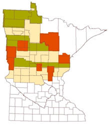
Legend for the map to the right:
- Green: One-half-meter (50-cm) imagery acquired in 2013
- Red: One-foot (30-cm) imagery acquired in 2013
- Tan: Acquired in 2014
AeroMetric (now Quantum Spatial) was selected as the project vendor from the responses to the RFP (State Register, 12/24/12 issue, p. 1006). The RFP specified all or part of 22 counties in central Minnesota; however, the bid was favorable enough that the Northwest counties were included in this phase. 2013 buy-up partnerships are shown in the map graphic; 2014 buy-up areas were Beltrami and Polk counties.
Project brochure (2 p., 570K, PDF)
Documentation:
View Imagery
The imagery is available via MnGeo's WMS image service in the following layers in either natural color ("color") or color-infrared ("cir"):
- 2013 NW 50 cm
- 2013 North 1 ft (the buy-up partnerships)
- 2014 NW 50 cm
- 2014 Polk Beltrami 1 ft (the buy-up partnerships)
Partnerships
The following partners contributed funding to obtain aerial photography at a higher resolution than the 50-centimeter baseline resolution funded by the State of Minnesota. Depending on how the size and arrangement of the buy-up areas influenced flight logistics, some areas were flown at both resolutions. Click on the map to see a larger version.
Areas flown only at 30-centimeter resolution:
- Beltrami County
- Carlton County
- Clay County
- Fond du Lac Band of Lake Superior Chippewa Reservation
- Itasca County: Portions of northern Itasca were also flown in 2009
- Mille Lacs County
- Polk County
- Wilkin County
Areas flown both at 30- and 50-centimeter resolutions:
- Camp Ripley Military Reservation
- White Earth Nation Reservation
Partnership Info Meetings
The SAIP Coordinating Team explored options for buy-up partnerships with counties and local governments at the following meetings:
- May 21, 2012, Brainerd
- Flyer
- Slides were the same as those in Bemidji, below
- April 3, 2012, Bemidji
- March 7, 2012,
Pine-to-Prairie User Group, Fergus Falls
- Slides,
Chris Cialek, Steve Kloiber and Pete Jenkins (38 slides, 8 MB, PPTX)
- Slides,
Chris Cialek, Steve Kloiber and Pete Jenkins (38 slides, 8 MB, PPTX)
Project Contacts
| MnGeo gisinfo.mngeo@state.mn.us |
Steve Kloiber, Project Coordinator National Wetlands Inventory Update Minnesota Department of Natural Resources 651-259-5164 steve.kloiber@state.mn.us |
Return to MnGeo's first-stop Aerial Photography page